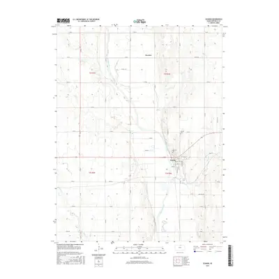
2015 Map of Scandia
USGS Topo · Published 2015About this map
Scandia is situated on the eastern banks of the Republican River, serving as a central hub in this agricultural landscape of Republic County. The town's grid is clearly defined by historical thoroughfares like Wyoming Ave and Washington St, leading toward the river’s edge. North of the primary settlement, the small community of Sherdahl and the Lutheran Cem mark the rural expanses, connected by a network of section-line roads such as Lincoln Rd and Co RD M. The terrain is shaped by the meandering river and its tributaries, including Mud Cr, Beaver Cr, and School Cr. These waterways cut through the section lines of t3s r4w and t2s r5w, defining the drainage patterns of the plains. Along the eastern edge, the Riverview Cem overlooks the valley, offering a point of interest for those documenting the area's local history and burial grounds.
Find a feature on this map
43 named features on this map. Tap any name to fly to it.
Don’t see what you’re looking for? This feature index may not catch every label — zoom into the map to look around manually.
Map Details
Editions of this 2015 Scandia Map
This is the sole edition of this map. No revisions or reprints were ever made.
Other maps of this area

1892 · Concordia
USGS Topo · 1:125,000

1955 · Manhattan
USGS Topo · 1:250,000

1956 · Manhattan
USGS Topo · 1:250,000

1957 · Manhattan
USGS Topo · 1:250,000

1965 · Concordia NW
USGS Topo · 1:24,000

1965 · Kackley
USGS Topo · 1:24,000

1966 · Scandia
USGS Topo · 1:24,000
1966 · Belleville
USGS Topo · 1:24,000
1968 · Jamestown NW
USGS Topo · 1:24,000
1968 · Belleville NW
USGS Topo · 1:24,000