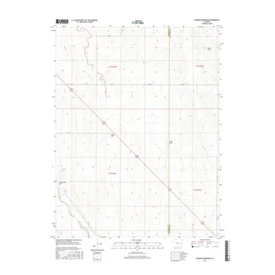
2016 Map of Schafer Reservoir
USGS Topo · Published 2016About this map
Big Sandy Creek winds through the southwestern corner of this Colorado landscape, cutting a path through the high plains near the border of Lincoln and Cheyenne counties. The terrain is defined by a network of drainage channels including Schoolhouse Gulch, Folger Gulch, and Aroya Gulch, which illustrate the natural watershed patterns of the region. This 2016 survey provides a clear view of the rural infrastructure, dominated by a strict grid of county roads such as Co RD 2l and Co RD 47. A primary point of interest is the Schafer Reservoir in the west, a vital water management feature in this arid environment. The map captures the intersection of natural topography and the Public Land Survey System, showing the township and range divisions of t12s r52w and t13s r52w.
Find a feature on this map
19 named features on this map. Tap any name to fly to it.
Don’t see what you’re looking for? This feature index may not catch every label — zoom into the map to look around manually.
Map Details
Editions of this 2016 Schafer Reservoir Map
This is the sole edition of this map. No revisions or reprints were ever made.
Other maps of this area

1891 · Arroyo
USGS Topo · 1:125,000

1893 · Arroyo
USGS Topo · 1:125,000

1954 · Limon
USGS Topo · 1:250,000

1954 · Lamar
USGS Topo · 1:250,000

1957 · Limon
USGS Topo · 1:250,000

1958 · Limon
USGS Topo · 1:250,000

1958 · Lamar
USGS Topo · 1:250,000

1978 · Aroya
USGS Topo · 1:24,000

1978 · Rock Basin
USGS Topo · 1:24,000

1978 · Sanders Ranch
USGS Topo · 1:24,000