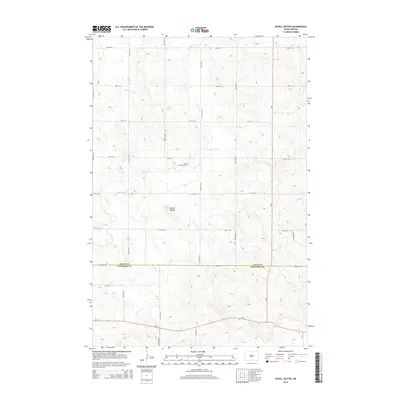
2014 Map of Schell Buttes
USGS Topo · Published 2014About this map
Saint Anthonys Cem sits near the upper reaches of Beaver Cr, marking a quiet cultural landmark in this section of the Great Plains. The terrain is characterized by the namesake Schell Buttes, which rise above the surrounding prairie landscape. This area, spanning the border of Logan and McIntosh Counties, remains primarily defined by its section-line road grid, including 72nd St SE and 26th Ave SE. The intersection of Nd-13 and Nd-3 in the southern portion of the quadrangle serves as a primary transit corridor through the rural expanse. The sparse distribution of named features emphasizes the agrarian and open character of the region, where family history is often tied to these isolated landmarks and the persistent flow of the creek.
Find a feature on this map
22 named features on this map. Tap any name to fly to it.
Don’t see what you’re looking for? This feature index may not catch every label — zoom into the map to look around manually.
Map Details
Editions of this 2014 Schell Buttes Map
This is the sole edition of this map. No revisions or reprints were ever made.
Other maps of this area

1953 · Jamestown
USGS Topo · 1:250,000

1956 · Jamestown
USGS Topo · 1:250,000

1979 · Schell Buttes
USGS Topo · 1:24,000

1979 · Schell Buttes SW
USGS Topo · 1:24,000

1979 · Schell Buttes NW
USGS Topo · 1:24,000

1979 · McKenna Lake South
USGS Topo · 1:24,000
1980 · Weisser Dam West
USGS Topo · 1:24,000

1982 · Wishek SW
USGS Topo · 1:24,000

1982 · May Lake NW
USGS Topo · 1:24,000

1982 · Burnstad
USGS Topo · 1:24,000