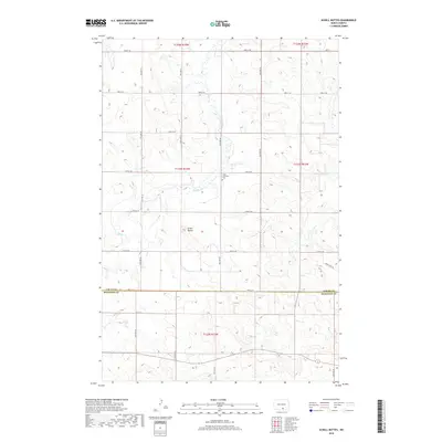
2018 Map of Schell Buttes
USGS Topo · Published 2018About this map
Schell Buttes rise above the undulating prairie of southern North Dakota, defining the landscape of Starkey Township near the border of Logan and McIntosh Counties. This 2018 survey documents a quiet rural expanse organized by a rigid section-line road grid, including 72nd St SE and 79th St SE. The area's agricultural character is evident in the sparse infrastructure, where the most prominent landmark is Saint Anthonys Cem situated near the headwaters of Beaver Cr. The map's detail provides a modern view of land ownership patterns and drainage networks in the Missouri Plateau region, showing how contemporary routes like John Deere Dr integrate with traditional section roads.
Find a feature on this map
19 named features on this map. Tap any name to fly to it.
Don’t see what you’re looking for? This feature index may not catch every label — zoom into the map to look around manually.
Map Details
Editions of this 2018 Schell Buttes Map
This is the sole edition of this map. No revisions or reprints were ever made.
Other maps of this area

1953 · Jamestown
USGS Topo · 1:250,000

1956 · Jamestown
USGS Topo · 1:250,000

1979 · Schell Buttes
USGS Topo · 1:24,000

1979 · Schell Buttes SW
USGS Topo · 1:24,000

1979 · Schell Buttes NW
USGS Topo · 1:24,000

1979 · McKenna Lake South
USGS Topo · 1:24,000
1980 · Weisser Dam West
USGS Topo · 1:24,000

1982 · Wishek SW
USGS Topo · 1:24,000

1982 · May Lake NW
USGS Topo · 1:24,000

1982 · Burnstad
USGS Topo · 1:24,000