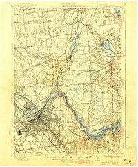
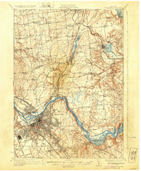
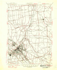
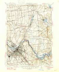
1930 Map of Schenectady
USGS Topo · Published 1941About this map
Schenectady serves as the industrial and transport heart of this landscape, situated at the confluence of several vital transit corridors during the late 1920s. The map illustrates a significant era of transition for New York's waterways, where the Erie Canal (Abandoned) runs parallel to the active Barge Canal along the Mohawk River. This dual-canal system, coupled with the heavy presence of the Delaware and Hudson RR and New York Central and Hudson River RR, highlights the region's importance as a gateway between the Hudson Valley and the West. To the north, the terrain shifts into a series of smaller hamlets and rural school districts, including Burnt Hills and Jonesville. The presence of the Airport near Scotia and the distinctive Aqueduct crossing point reflect the modernization of the capital region as it grew outward into Clifton Park and Niskayuna townships.
Find a feature on this map
90 named features on this map. Tap any name to fly to it.
Don’t see what you’re looking for? This feature index may not catch every label — zoom into the map to look around manually.
Map Details
Editions of this 1930 Schenectady Map
5 editions found

Other maps of this area

1893 · Cohoes
USGS Topo · 1:62,500

1893 · Troy
USGS Topo · 1:62,500

1893 · Schenectady
USGS Topo · 1:62,500

1893 · Albany
USGS Topo · 1:62,500

1895 · Troy
USGS Topo · 1:62,500

1895 · Cohoes
USGS Topo · 1:62,500

1895 · Albany
USGS Topo · 1:62,500

1895 · Schenectady
USGS Topo · 1:62,500

1895 · Amsterdam
USGS Topo · 1:62,500

1898 · Schenectady
USGS Topo · 1:62,500