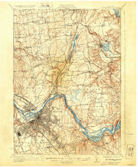
1930 Map of Schenectady
USGS Topo · Published 1932About this map
The Mohawk River corridor serves as the industrial and transit spine of this region during the mid-1920s, showing the complex evolution of New York's waterway history. In the city of Schenectady, the dense urban grid meets the riverbank where the Erie Canal (Abandoned) and the modern Barge Canal trace the landscape's transformation. Key infrastructure of the era, such as the Aqueduct and the Airport near Alplaus, indicate a period of rapid technological shift. To the north, the landscape transitions into a network of rural hamlets and agricultural townships including Clifton Park, Charlton, and Ballston. This survey, compiled in part from early Army Air Corps aerial photography, captures a moment when local life was anchored by institutions like Charlton Farm Sch, White Ch, and numerous numbered schoolhouses. The rail network, including the Delaware and Hudson and the Boston and Maine, connects these small communities to the regional hubs of Scotia and Rotterdam.
Find a feature on this map
81 named features on this map. Tap any name to fly to it.
Don’t see what you’re looking for? This feature index may not catch every label — zoom into the map to look around manually.
Map Details
Editions of this 1930 Schenectady Map
5 editions found

Other maps of this area

1893 · Cohoes
USGS Topo · 1:62,500

1893 · Troy
USGS Topo · 1:62,500

1893 · Schenectady
USGS Topo · 1:62,500

1893 · Albany
USGS Topo · 1:62,500

1895 · Troy
USGS Topo · 1:62,500

1895 · Cohoes
USGS Topo · 1:62,500

1895 · Albany
USGS Topo · 1:62,500

1895 · Schenectady
USGS Topo · 1:62,500

1895 · Amsterdam
USGS Topo · 1:62,500

1898 · Schenectady
USGS Topo · 1:62,500