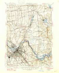
1930 Map of Schenectady
USGS Topo · Published 1947About this map
Industrial and transit lines converge at Schenectady along the banks of the Mohawk River, where the transition from the Erie Canal (Abandoned) to the modern Barge Canal is clearly visible. This survey, compiled in part from Air Corps aerial photography, captures the dense rail networks of the New York Central and Hudson River and the Delaware and Hudson railroads as they facilitated the movement of goods and people through the Mohawk Valley. North of the city, the landscape transitions into a series of smaller hamlets such as Alplaus, Rexford, and Saint Hills. The map provides specific location data for numerous local institutions, from the White Ch near Groom Corners to a dense concentration of numbered district schools like School No 10 and School No 11, offering a detailed view of the rural social structure in Saratoga and Schenectady Counties between the world wars.
Find a feature on this map
101 named features on this map. Tap any name to fly to it.
Don’t see what you’re looking for? This feature index may not catch every label — zoom into the map to look around manually.
Map Details
Editions of this 1930 Schenectady Map
5 editions found

Other maps of this area

1893 · Cohoes
USGS Topo · 1:62,500

1893 · Troy
USGS Topo · 1:62,500

1893 · Schenectady
USGS Topo · 1:62,500

1893 · Albany
USGS Topo · 1:62,500

1895 · Troy
USGS Topo · 1:62,500

1895 · Cohoes
USGS Topo · 1:62,500

1895 · Albany
USGS Topo · 1:62,500

1895 · Schenectady
USGS Topo · 1:62,500

1895 · Amsterdam
USGS Topo · 1:62,500

1898 · Schenectady
USGS Topo · 1:62,500