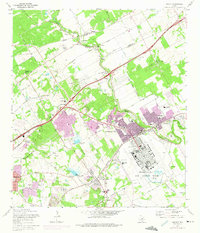
1967 Map of Schertz
USGS Topo · Published 1975About this map
Randolph Air Force Base dominates the southeastern quadrant of this landscape, its distinctive circular street patterns and airfield infrastructure contrasting with the expanding residential developments of Universal City and Schertz. The 1973 revisions, highlighted in purple, reveal a period of rapid suburban growth between San Antonio and the Cibolo Creek corridor. These updates show the expansion of neighborhoods near Windcrest and Live Oak, where once-rural lands were being partitioned into housing tracts and shopping centers.
Find a feature on this map
80 named features on this map. Tap any name to fly to it.
Don’t see what you’re looking for? This feature index may not catch every label — zoom into the map to look around manually.
Map Details
Editions of this 1967 Schertz Map
2 editions found
Other maps of this area

1927 · New Braunfels
USGS Topo · 1:62,500

1953 · Schertz
USGS Topo · 1:24,000

1953 · Bulverde
USGS Topo · 1:24,000

1953 · San Antonio East
USGS Topo · 1:24,000

1953 · Bat Cave
USGS Topo · 1:24,000

1953 · Longhorn
USGS Topo · 1:24,000

1953 · Martinez
USGS Topo · 1:24,000

1954 · San Antonio
USGS Topo · 1:250,000

1957 · San Antonio
USGS Topo · 1:250,000

1958 · Marion
USGS Topo · 1:24,000