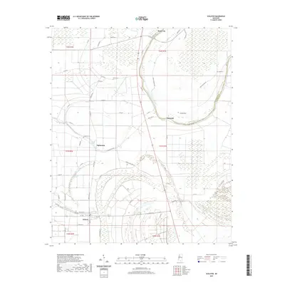
2020 Map of Schlater
USGS Topo · Published 2020About this map
Schlater sits at the southern edge of this Mississippi Delta landscape, where a dense network of county roads like Schlater Rd and Walker Rd connects small agricultural communities. The terrain is defined by the slow-moving water of Marsh Bayou and distinctive wetland depressions such as Buckhorn Brake and Ashland Brake. To the north, the settlement of Minter City marks a historic crossroads near the Tallahatchie Co / Leflore Co boundary line. Genealogists will find several burial sites preserved on the landscape, including Watkins Cem, Shiloh Cem, and Humphrey Cem, which are scattered among the fields. The looping path of the river creates prominent landforms like Eutah Bend, reflecting the hydrologic history of a region shaped by its alluvial origins and long-standing cotton-farming heritage.
Find a feature on this map
63 named features on this map. Tap any name to fly to it.
Don’t see what you’re looking for? This feature index may not catch every label — zoom into the map to look around manually.
Map Details
Editions of this 2020 Schlater Map
This is the sole edition of this map. No revisions or reprints were ever made.
Other maps of this area

1931 · Schlater
USGS Topo · 1:48,000

1931 · Sumner
USGS Topo · 1:48,000

1932 · Philipp
USGS Topo · 1:48,000

1934 · Schlater
USGS Topo · 1:62,500

1935 · Sumner
USGS Topo · 1:62,500

1935 · Philipp
USGS Topo · 1:62,500

1936 · Greenwood
USGS Topo · 1:62,500

1939 · Schlater
USGS Topo · 1:62,500

1939 · Sumner
USGS Topo · 1:62,500

1939 · Philipp
USGS Topo · 1:62,500