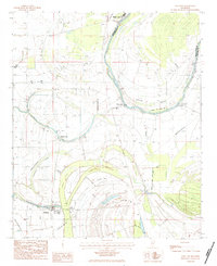
1983 Map of Schlater
USGS Topo · Published 1984About this map
The Tallahatchie River dominates this landscape, winding through a series of dramatic loops including Eutah Bend as it separates Leflore and Tallahatchie counties. In the early 1980s, the region was defined by its alluvial wetlands and water management, with numerous cypress-heavy brakes like Ashland Brake and Buckhorn Brake positioned alongside the river’s path. The settlement of Schlater sits in the southwestern corner, flanked by McNutt Lake and the river's protective Levee system.
Find a feature on this map
23 named features on this map. Tap any name to fly to it.
Don’t see what you’re looking for? This feature index may not catch every label — zoom into the map to look around manually.
Map Details
Editions of this 1983 Schlater Map
This is the sole edition of this map. No revisions or reprints were ever made.
Other maps of this area

1931 · Schlater
USGS Topo · 1:48,000

1931 · Sumner
USGS Topo · 1:48,000

1932 · Philipp
USGS Topo · 1:48,000

1934 · Schlater
USGS Topo · 1:62,500

1935 · Sumner
USGS Topo · 1:62,500

1935 · Philipp
USGS Topo · 1:62,500

1936 · Greenwood
USGS Topo · 1:62,500

1939 · Schlater
USGS Topo · 1:62,500

1939 · Sumner
USGS Topo · 1:62,500

1939 · Philipp
USGS Topo · 1:62,500