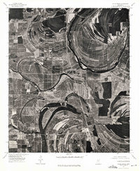
1974 Map of Schlater NE
USGS Topo · Published 1975About this map
Schlater anchors the southwestern corner of this 1974 orthophotograph, where the intricate meanders of the Mississippi Delta landscape are visible in stark photographic detail. This specialized sheet, produced by the U.S. Geological Survey using imagery from October 1974, emphasizes the agricultural patterns and hydrologic complexity of Leflore County. The rectified imagery reveals the distinct scrollwork of old river bends and oxbows, which by the mid-1970s had been largely integrated into a highly structured system of fields and drainage. This specific type of survey provides a unique look at how the Delta was being farmed and managed just before the digital era, capturing the exact footprint of farm structures, tree lines, and dirt tracks that standard topographic line maps often generalize.
Find a feature on this map
1 named feature on this map. Tap any name to fly to it.
Don’t see what you’re looking for? This feature index may not catch every label — zoom into the map to look around manually.
Map Details
Editions of this 1974 Schlater NE Map
This is the sole edition of this map. No revisions or reprints were ever made.
Other maps of this area

1931 · Schlater
USGS Topo · 1:48,000

1931 · Sumner
USGS Topo · 1:48,000

1932 · Philipp
USGS Topo · 1:48,000

1934 · Schlater
USGS Topo · 1:62,500

1935 · Sumner
USGS Topo · 1:62,500

1935 · Philipp
USGS Topo · 1:62,500

1936 · Greenwood
USGS Topo · 1:62,500

1939 · Schlater
USGS Topo · 1:62,500

1939 · Sumner
USGS Topo · 1:62,500

1939 · Philipp
USGS Topo · 1:62,500