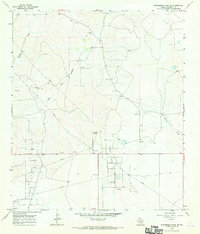
1967 Map of Schneeman Draw NE
USGS Topo · Published 1970About this map
The Midway Lane Oil Field and the Elkhorn Oil Field dominate the southern landscape of this Crockett County quadrangle, illustrating the intensive industrial development of West Texas in the late 1960s. A network of pipelines and numerous well sites cross the terrain, supporting the central Gas Plant. This era was defined by the expansion of petroleum infrastructure into the remote draws and uplands of the Edwards Plateau. The natural geography is characterized by several major drainage systems, including Howard Draw, its East Fork, and Johnson Draw. While the oil industry is the most prominent human footprint, the map also identifies multiple locations for a Gravel Pit, suggesting secondary extraction industries supporting the road networks required to service the sprawling energy fields.
Find a feature on this map
9 named features on this map. Tap any name to fly to it.
Don’t see what you’re looking for? This feature index may not catch every label — zoom into the map to look around manually.
Map Details
Editions of this 1967 Schneeman Draw NE Map
This is the sole edition of this map. No revisions or reprints were ever made.
Other maps of this area

1920 · Big Lake
USGS Topo · 1:62,500

1920 · Barnhart
USGS Topo · 1:62,500

1922 · Big Lake
USGS Topo · 1:62,500

1922 · Barnhart
USGS Topo · 1:62,500

1954 · Sonora
USGS Topo · 1:250,000

1954 · San Angelo
USGS Topo · 1:250,000

1958 · Sonora
USGS Topo · 1:250,000

1958 · San Angelo
USGS Topo · 1:250,000

1965 · San Angelo
USGS Topo · 1:250,000

1967 · Schneeman Draw NW
USGS Topo · 1:24,000