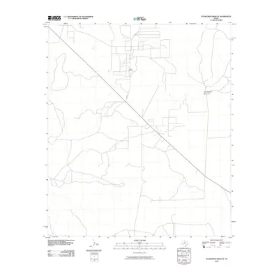
2010 Map of Schneeman Draw SE
USGS Topo · Published 2010About this map
Vaughn Oil Field dominates the central portion of this West Texas quadrangle, signifying the importance of the local extraction economy within Crockett County. The landscape is structured by a network of ranch and access roads, including Co RD 204, which navigate the arid terrain. Water management is a critical feature of this environment, evidenced by the Soil Conservation Service Site 3 Dam in the northeast. This infrastructure reflects regional efforts to manage runoff and erosion in a landscape defined by intermittent draws and drainage patterns typical of the Edwards Plateau. The sparse distribution of named features underscores the isolated and utilitarian nature of this ranchland at the turn of the 21st century.
Find a feature on this map
3 named features on this map. Tap any name to fly to it.
Don’t see what you’re looking for? This feature index may not catch every label — zoom into the map to look around manually.
Map Details
Editions of this 2010 Schneeman Draw SE Map
This is the sole edition of this map. No revisions or reprints were ever made.
Other maps of this area

1954 · Sonora
USGS Topo · 1:250,000

1958 · Sonora
USGS Topo · 1:250,000

1967 · Ozona
USGS Topo · 1:24,000

1967 · Schneeman Draw NW
USGS Topo · 1:24,000
1967 · Schneeman Draw NE
USGS Topo · 1:24,000

1967 · Pikes Peak
USGS Topo · 1:24,000
1967 · Schneeman Draw SW
USGS Topo · 1:24,000

1967 · Indio Hill
USGS Topo · 1:24,000

1967 · Double Mill Draw NW
USGS Topo · 1:24,000
1967 · Schneeman Draw SE
USGS Topo · 1:24,000