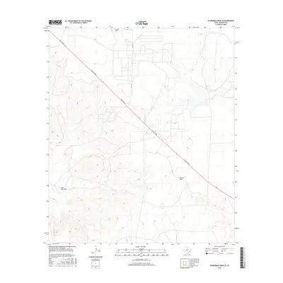
2016 Map of Schneeman Draw SE
USGS Topo · Published 2016About this map
The arid drainage patterns of west Texas define this landscape in Crockett County, where seasonal watercourses like Newton Draw and Garrett Draw carve subtle relief into the terrain. This 2016 survey illustrates a sparse ranching environment, largely inaccessible except for a few arterial routes. Ranch Rd 865 cuts diagonally across the quadrangle, serving as the primary link through this segment of the Edwards Plateau. Near the western edge, Pikes Peak Draw highlights the localized nomenclature given to these intermittent streams, while Co Rd 204 provides a secondary northern access point. The map is a study in isolation and natural drainage, where the placement of roads and the naming of dry draws reveal the essential landmarks of a cattle-country landscape in the early 21st century.
Find a feature on this map
5 named features on this map. Tap any name to fly to it.
Don’t see what you’re looking for? This feature index may not catch every label — zoom into the map to look around manually.
Map Details
Editions of this 2016 Schneeman Draw SE Map
This is the sole edition of this map. No revisions or reprints were ever made.
Other maps of this area

1954 · Sonora
USGS Topo · 1:250,000

1958 · Sonora
USGS Topo · 1:250,000

1967 · Ozona
USGS Topo · 1:24,000

1967 · Schneeman Draw NW
USGS Topo · 1:24,000
1967 · Schneeman Draw NE
USGS Topo · 1:24,000

1967 · Pikes Peak
USGS Topo · 1:24,000
1967 · Schneeman Draw SW
USGS Topo · 1:24,000

1967 · Indio Hill
USGS Topo · 1:24,000

1967 · Double Mill Draw NW
USGS Topo · 1:24,000
1967 · Schneeman Draw SE
USGS Topo · 1:24,000