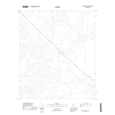
2019 Map of Schneeman Draw SE
USGS Topo · Published 2019About this map
Ranch Rd 865 cuts a long, diagonal path through this remote corner of Crockett County, defining the primary transportation artery for a landscape shaped by arid drainage patterns. The topography is dominated by several significant intermittent watercourses, including Garrett Draw in the northeast and Pikes Peak Draw to the west. These seasonal features, along with Newton Draw, trace the low points of the terrain where water occasionally flows toward the Pecos River basin. Aside from the main ranch road and Co Rd 204, the map reveals a sparse network of private tracks and ranching infrastructure typical of the Edwards Plateau. This 2019 survey provides a clear look at the modern land use and drainage systems in a region where geography is dictated by the availability of water and the orientation of its major draws.
Find a feature on this map
5 named features on this map. Tap any name to fly to it.
Don’t see what you’re looking for? This feature index may not catch every label — zoom into the map to look around manually.
Map Details
Editions of this 2019 Schneeman Draw SE Map
This is the sole edition of this map. No revisions or reprints were ever made.
Other maps of this area

1954 · Sonora
USGS Topo · 1:250,000

1958 · Sonora
USGS Topo · 1:250,000

1967 · Ozona
USGS Topo · 1:24,000

1967 · Schneeman Draw NW
USGS Topo · 1:24,000
1967 · Schneeman Draw NE
USGS Topo · 1:24,000

1967 · Pikes Peak
USGS Topo · 1:24,000
1967 · Schneeman Draw SW
USGS Topo · 1:24,000

1967 · Indio Hill
USGS Topo · 1:24,000

1967 · Double Mill Draw NW
USGS Topo · 1:24,000
1967 · Schneeman Draw SE
USGS Topo · 1:24,000