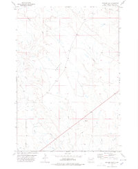
1978 Map of Schoepp Flat
USGS Topo · Published 1978About this map
Schoepp Flat dominates this high-plains landscape in Butte County, reflecting a topography defined by complex drainage networks and early water management infrastructure. The survey illustrates the reliance on diverted water for this arid region, highlighted by the presence of the North Canal and a supporting Lateral system in the southwest corner. The natural drainage of the area is characterized by several meandering waterways, including Willow Creek, Jug Creek, and Sand Creek, which carve through the terrain towards larger collectors like South Double R Creek and Butte Creek. This map captures a moment in the late 1970s when the land was primarily organized around these vital water sources and topographic flats, serving as an essential record for those studying the intersection of Western water rights and traditional ranching geography.
Find a feature on this map
8 named features on this map. Tap any name to fly to it.
Don’t see what you’re looking for? This feature index may not catch every label — zoom into the map to look around manually.
Map Details
Editions of this 1978 Schoepp Flat Map
This is the sole edition of this map. No revisions or reprints were ever made.
Other maps of this area

1906 · Vale
USGS Topo · 1:62,500

1913 · Newell
USGS Topo · 1:125,000

1951 · Newell
USGS Topo · 1:24,000

1951 · Vale NE
USGS Topo · 1:24,000

1951 · Vale
USGS Topo · 1:62,500

1953 · Rapid City
USGS Topo · 1:250,000

1957 · Rapid City
USGS Topo · 1:250,000
1959 · Volunteer NW
USGS Topo · 1:24,000
1973 · Owl Butte
USGS Topo · 1:24,000
1977 · Castle Rock
USGS Topo · 1:24,000