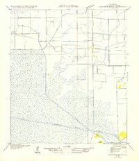
1954 Map of Schooner Bayou NW
USGS Topo · Published 1954About this map
The vast marshlands and coastal prairies of southern Vermilion Parish are defined here by a network of drainage and transportation canals essential to the local economy. The Intracoastal Waterway cuts a straight path through the wetland, intersecting with several local arteries including Spencer Canal, Robins Canal, and Sledge Canal. These waterways, along with the Warren Trail, reflect the engineering efforts required to navigate and utilize this low-lying landscape during the mid-20th century.
Find a feature on this map
11 named features on this map. Tap any name to fly to it.
Don’t see what you’re looking for? This feature index may not catch every label — zoom into the map to look around manually.
Map Details
Editions of this 1954 Schooner Bayou NW Map
This is the sole edition of this map. No revisions or reprints were ever made.
Other maps of this area

1946 · Morse
USGS Topo · 1:31,680

1946 · Schooner Bayou SE
USGS Topo · 1:31,680

1946 · Schooner Bayou NE
USGS Topo · 1:31,680

1946 · Schooner Bayou NW
USGS Topo · 1:31,680

1946 · Kaplan
USGS Topo · 1:31,680

1946 · Schooner Bayou SW
USGS Topo · 1:31,680

1949 · Gueydan
USGS Topo · 1:31,680

1952 · Lake Charles
USGS Topo · 1:250,000

1953 · Jacks Point Island
USGS Topo · 1:24,000

1954 · Grand Lake East SE
USGS Topo · 1:31,680