
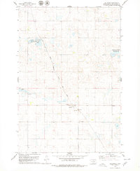
1978 Map of Schumacher Lake SW
USGS Topo · Published 1979About this map
Glacial prairie potholes and seasonal wetlands dominate this corner of McPherson County, where a complex network of conservation lands supports regional migratory bird populations. Numerous public shooting areas, including Neuharth State Public Shooting Area and Rosenthal State Public Shooting Area, are interspersed with federal National Waterfowl Production Area parcels, reflecting a landscape heavily managed for wildlife and hunting by the late 1970s. The region is largely defined by its natural hydrology, with Morlocks Slough State Public Shooting Area and the two Odessa public areas marking significant water bodies. Evidence of the early pioneer settlement remains at Glueckstahl Cem and Calvin Cem, while several Gravel Pits and numerous marked wells indicate the rural infrastructure supporting the surrounding agricultural community.
Find a feature on this map
13 named features on this map. Tap any name to fly to it.
Don’t see what you’re looking for? This feature index may not catch every label — zoom into the map to look around manually.
Map Details
Editions of this 1978 Schumacher Lake SW Map
This is the sole edition of this map. No revisions or reprints were ever made.
Other maps of this area

1954 · Aberdeen
USGS Topo · 1:250,000

1956 · Aberdeen
USGS Topo · 1:250,000

1978 · Wolff Lake
USGS Topo · 1:24,000

1978 · Hosmer NW
USGS Topo · 1:24,000

1978 · Hosmer NE
USGS Topo · 1:24,000

1978 · Venturia
USGS Topo · 1:24,000

1978 · Eureka East
USGS Topo · 1:24,000

1978 · Schumacher Lake
USGS Topo · 1:24,000
1978 · Hillsview
USGS Topo · 1:24,000

1978 · Schumacher Lake NE
USGS Topo · 1:24,000