
1951 Map of Schuster Flats NW
USGS Topo · Published 1952About this map
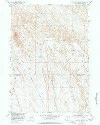
Red Butte stands as a prominent landmark in this desert-like landscape of the Bighorn Basin during the early 1950s. The terrain is defined by a dense network of seasonal drainage patterns, where the Fivemile Creek and the North Fork Fifteennile Creek have carved intricate coulees through the sedimentary layers. This area, surveyed as part of the Department of the Interior program for the development of the Missouri River Basin, reveals a landscape largely devoid of permanent settlement, focused instead on the natural topography at the border of Big Horn Co and Washakie Co. The map illustrates the complex watershed system of the region, including the headwaters of the Middle Fork Tenmile Creek, providing a detailed record of the erosion patterns and landforms that characterize this portion of north-central Wyoming.
Find a feature on this map
5 named features on this map. Tap any name to fly to it.
Don’t see what you’re looking for? This feature index may not catch every label — zoom into the map to look around manually.
Map Details
Editions of this 1951 Schuster Flats NW Map
2 editions found
Other maps of this area

1951 · Sucker Dam
USGS Topo · 1:24,000

1951 · Schuster Flats NE
USGS Topo · 1:24,000

1951 · Dutch Nick Flat
USGS Topo · 1:24,000

1951 · Schuster Flats
USGS Topo · 1:24,000

1951 · Schuster Flats SE
USGS Topo · 1:24,000

1951 · Wardel Reservoir
USGS Topo · 1:24,000

1955 · Cody
USGS Topo · 1:250,000

1958 · Cody
USGS Topo · 1:250,000

1962 · Cody
USGS Topo · 1:250,000
1966 · Orchard Bench
USGS Topo · 1:24,000