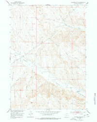
1951 Map of Schuster Flats SE
USGS Topo · Published 1978About this map
Schuster Flats dominates the landscape of Washakie County in this mid-century survey, a region defined by an intricate network of drainage draws and high desert terrain. The map captures the essential water management infrastructure of the Missouri River Basin development, most notably where the Big Horn Canal cuts through the southeastern corner. This irrigation artery is supported by technical features like the Fifteenmile Siphon and a Gaging Sta, illustrating the 1950s effort to harness the arid environment for agricultural use.
Find a feature on this map
15 named features on this map. Tap any name to fly to it.
Don’t see what you’re looking for? This feature index may not catch every label — zoom into the map to look around manually.
Map Details
Editions of this 1951 Schuster Flats SE Map
3 editions found
Other maps of this area

1945 · Kirby
USGS Topo · 1:62,500

1946 · Kirby
USGS Topo · 1:62,500

1951 · Schuster Flats NE
USGS Topo · 1:24,000

1951 · Schuster Flats
USGS Topo · 1:24,000

1951 · Schuster Flats NW
USGS Topo · 1:24,000

1951 · Schuster Flats SE
USGS Topo · 1:24,000

1955 · Cody
USGS Topo · 1:250,000

1955 · Thermopolis
USGS Topo · 1:250,000

1955 · Sheridan
USGS Topo · 1:250,000

1955 · Arminto
USGS Topo · 1:250,000