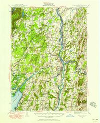
1947 Map of Schuylerville
USGS Topo · Published 1958About this map
The Hudson River corridor near Schuylerville and Greenwich defines this post-war landscape, where the legacy of the American Revolution is preserved at Saratoga National Historical Park. The survey captures a moment of transition for local infrastructure, noting the Hudson Valley RR (Abandoned) alongside the active Greenwich and Johnsonville RR and the Champlain Canal. Settlement patterns are densely clustered in villages like Victory Mills and Gansevoort, while the upland terrain features family landmarks such as Kendrick Hill and Palmer Ridge. Cultural and public sites are well-documented, from the Saratoga Battle Monument to the New York State Veterans Hospital near Mount McGregor. For genealogists, the map is a primary resource for locating vanished rural institutions, including numerous numbered schoolhouses and family-associated crossings like Jewel Corner and Ballard Corners.
Find a feature on this map
122 named features on this map. Tap any name to fly to it.
Don’t see what you’re looking for? This feature index may not catch every label — zoom into the map to look around manually.
Map Details
Editions of this 1947 Schuylerville Map
3 editions found
Other maps of this area

1893 · Cohoes
USGS Topo · 1:62,500

1893 · Schenectady
USGS Topo · 1:62,500

1893 · Fort Ann
USGS Topo · 1:62,500

1895 · Cohoes
USGS Topo · 1:62,500

1895 · Cambridge
USGS Topo · 1:62,500

1895 · Fort Ann
USGS Topo · 1:62,500

1895 · Schenectady
USGS Topo · 1:62,500

1895 · Glens Falls
USGS Topo · 1:62,500

1897 · Glens Falls
USGS Topo · 1:62,500

1897 · Hoosick
USGS Topo · 1:62,500