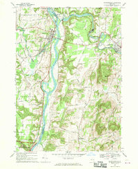
1967 Map of Schuylerville
USGS Topo · Published 1970About this map
The Hudson River serves as the central artery for this landscape in the late 1960s, flanked by the industrial and transport corridors of the Champlain Canal and the Greenwich and Johnsonville RR. Centered on Schuylerville, the map reveals a region defined by its water power and revolutionary history, with the northern edge of Saratoga National Historical Park appearing in the southwest. The presence of Victory Mills and Middle Falls along the Batten Kill illustrates the enduring legacy of 19th-century river-based industry. Beyond the river valleys, the terrain rises into the tactical heights of Whelden Mtn and Willard Mtn. Local genealogy and land-use patterns are preserved through detailed labels for family-named roads like Hanehan Rd and Becker Road, alongside historic landmarks such as Starks Knob and the Schuylerville Prep Sch.
Find a feature on this map
74 named features on this map. Tap any name to fly to it.
Don’t see what you’re looking for? This feature index may not catch every label — zoom into the map to look around manually.
Map Details
Editions of this 1967 Schuylerville Map
This is the sole edition of this map. No revisions or reprints were ever made.
Other maps of this area

1893 · Cohoes
USGS Topo · 1:62,500

1895 · Cohoes
USGS Topo · 1:62,500

1895 · Cambridge
USGS Topo · 1:62,500

1897 · Hoosick
USGS Topo · 1:62,500

1898 · Cambridge
USGS Topo · 1:62,500

1898 · Cohoes
USGS Topo · 1:62,500

1900 · Taconic
USGS Topo · 1:125,000

1900 · Schuylerville
USGS Topo · 1:62,500

1901 · Cambridge
USGS Topo · 1:62,500

1903 · Mettawee
USGS Topo · 1:125,000