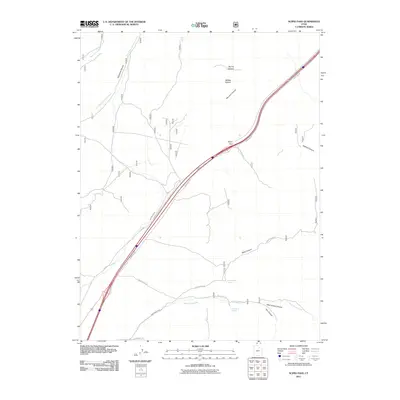
2011 Map of Scipio Pass
USGS Topo · Published 2011About this map
Scipio Pass serves as the central crossing point in this Millard County landscape, where modern transportation corridors follow the natural contours of the high desert terrain. The contemporary Frontage Rd and highway systems trace a path that historically connected the Sevier Valley with the northern territories, a route echoed by the nearby Scipio Pioneer Trl. This area is defined by its complex drainage network, where seasonal water sources like Mud Spring and Lower Ebbs Spring feed into systems such as Wild Goose Creek. The topography is dominated by numerous deep cut features including Eightmile Canyon and Ebbs Canyon, illustrating the erosional forces that have shaped the West. For the local historian, the map reveals the persistence of named landmarks and cattle-era infrastructure like the East Fork Ditch and various rural access points including Wild Goose Rd.
Find a feature on this map
22 named features on this map. Tap any name to fly to it.
Don’t see what you’re looking for? This feature index may not catch every label — zoom into the map to look around manually.
Map Details
Editions of this 2011 Scipio Pass Map
This is the sole edition of this map. No revisions or reprints were ever made.
Other maps of this area

1885 · Sevier Desert
USGS Topo · 1:250,000

1951 · Oak City
USGS Topo · 1:62,500

1952 · Scipio North
USGS Topo · 1:62,500

1953 · Delta
USGS Topo · 1:250,000

1958 · Delta
USGS Topo · 1:250,000

1962 · Delta
USGS Topo · 1:250,000
1962 · Holden
USGS Topo · 1:24,000

1962 · Holden
USGS Topo · 1:62,500
1969 · Scipio Lake
USGS Topo · 1:24,000
1969 · Scipio Pass
USGS Topo · 1:24,000