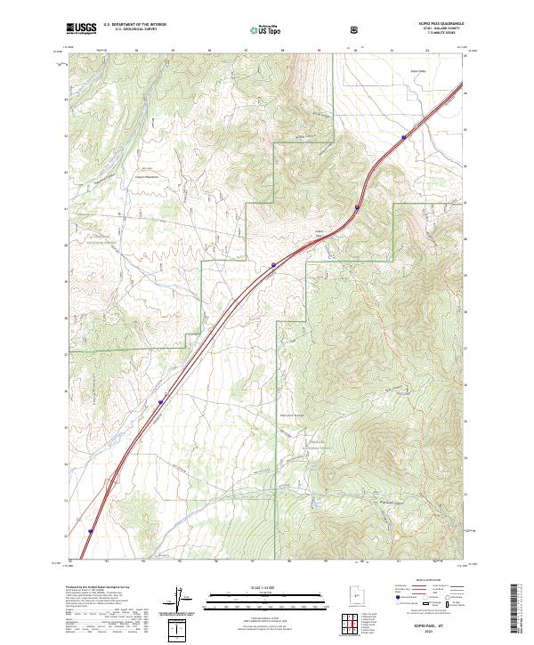
2023 Map of Scipio Pass
USGS Topo · Published 2023About this map
Scipio Pass serves as a critical topographic saddle between the Canyon Mountains to the north and the Pahvant Range to the south. This modern survey illustrates the transit corridor through the heart of Millard County, where the historic Scipio Pioneer Trl once guided travelers across this high desert terrain. The landscape is defined by deep drainages like Eightmile Canyon and Ebbs Canyon, where seasonal waters and permanent sources like Mud Spring and Wild Goose Spring provided essential relief for livestock and early travelers. The western edge of the Fishlake National Forest blankets the higher elevations, while irrigation features like the East Fork Ditch in the southwest corner reflect the ongoing human effort to manage water in the arid Scipio Valley. Several mapped trails, including the Coffee Peak-Scipio Pass Trl, highlight the area's continued importance for mountain access and navigation.
Find a feature on this map
34 named features on this map. Tap any name to fly to it.
Don’t see what you’re looking for? This feature index may not catch every label — zoom into the map to look around manually.
Map Details
Editions of this 2023 Scipio Pass Map
This is the sole edition of this map. No revisions or reprints were ever made.
Other maps of this area

1885 · Sevier Desert
USGS Topo · 1:250,000

1951 · Oak City
USGS Topo · 1:62,500

1952 · Scipio North
USGS Topo · 1:62,500

1953 · Delta
USGS Topo · 1:250,000

1958 · Delta
USGS Topo · 1:250,000

1962 · Delta
USGS Topo · 1:250,000
1962 · Holden
USGS Topo · 1:24,000

1962 · Holden
USGS Topo · 1:62,500
1969 · Scipio Lake
USGS Topo · 1:24,000
1969 · Scipio Pass
USGS Topo · 1:24,000