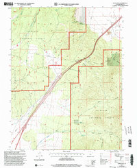
2001 Map of Scipio Pass
USGS Topo · Published 2003About this map
Scipio Pass serves as a critical geographic gateway between the Church Mountains and the northern reaches of the Fishlake National Forest. At the start of the 21st century, this high-desert landscape in Millard County shows a complex intersection of natural drainage systems and modern utility infrastructure. Seasonal water sources like Scipio Spring and Mud Spring define the rugged terrain, while a high-voltage Powerline and a Pipeline trace the valley floors alongside the primary transport corridor. Local resource extraction and development are evident through multiple Gravel Pits, a Prospect located near Ebbs Canyon, and a prominent Substation in the northeast. The map captures the delicate balance of public forest land and essential utility rights-of-way, with numerous 4wd tracks providing access into deeper canyons like Middle Canyon and Wild Goose Canyon.
Find a feature on this map
27 named features on this map. Tap any name to fly to it.
Don’t see what you’re looking for? This feature index may not catch every label — zoom into the map to look around manually.
Map Details
Editions of this 2001 Scipio Pass Map
This is the sole edition of this map. No revisions or reprints were ever made.
Other maps of this area

1885 · Sevier Desert
USGS Topo · 1:250,000

1951 · Oak City
USGS Topo · 1:62,500

1952 · Scipio North
USGS Topo · 1:62,500

1953 · Delta
USGS Topo · 1:250,000

1958 · Delta
USGS Topo · 1:250,000

1962 · Delta
USGS Topo · 1:250,000
1962 · Holden
USGS Topo · 1:24,000

1962 · Holden
USGS Topo · 1:62,500
1969 · Scipio Lake
USGS Topo · 1:24,000
1969 · Scipio Pass
USGS Topo · 1:24,000