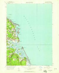
1947 Map of Scituate
USGS Topo · Published 1958About this map
Scituate Harbor serves as the focal point for this coastal survey, where the town’s maritime character is defined by a series of prominent drumlins known as First Cliff, Second Cliff, and Third Cliff. The post-war landscape shows a settled shoreline extending through Shore Acres and Sand Hills, while the interior retains its rail connections via the New York New Haven and Hartford line, including the Scituate Sta and the village of Greenbush.
Find a feature on this map
65 named features on this map. Tap any name to fly to it.
Don’t see what you’re looking for? This feature index may not catch every label — zoom into the map to look around manually.
Map Details
Editions of this 1947 Scituate Map
This is the sole edition of this map. No revisions or reprints were ever made.
Other maps of this area

1885 · Abington
USGS Topo · 1:62,500

1885 · Duxbury
USGS Topo · 1:62,500

1888 · Duxbury
USGS Topo · 1:62,500

1888 · Abington
USGS Topo · 1:62,500

1892 · Boston Bay
USGS Topo · 1:62,500

1893 · Abington
USGS Topo · 1:62,500

1893 · Duxbury
USGS Topo · 1:62,500

1903 · Boston Bay
USGS Topo · 1:62,500

1918 · Duxbury
USGS Topo · 1:62,500

1920 · Abington
USGS Topo · 1:62,500