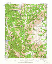
1923 Map of Scofield
USGS Topo · Published 1965About this map
The Scofield area of the Wasatch Plateau is defined by an intensive coal mining economy at the time of these 1921 and 1923 surveys. The Denver & Rio Grande Western railroad tracks follow Mud Creek through the narrow valley, serving a string of industrial sites including the Utah Mine, Gibson Mine, and the extensive Clear Creek Mines No 4 No 3. These operations are tucked into steep canyons such as Winter Quarters Canyon and Eccles Canyon, revealing the rugged geography that dictated the placement of early Utah mining camps.
Find a feature on this map
92 named features on this map. Tap any name to fly to it.
Don’t see what you’re looking for? This feature index may not catch every label — zoom into the map to look around manually.
Map Details
Editions of this 1923 Scofield Map
2 editions found
Other maps of this area

1885 · Manti
USGS Topo · 1:250,000

1886 · Price River
USGS Topo · 1:250,000

1895 · Manti
USGS Topo · 1:250,000

1896 · Price River
USGS Topo · 1:250,000

1914 · Castle Gate
USGS Topo · 1:62,500

1916 · Castle Gate
USGS Topo · 1:62,500

1923 · Scofield
USGS Topo · 1:62,500

1923 · Hiawatha
USGS Topo · 1:62,500

1925 · Scofield
USGS Topo · 1:62,500

1925 · Hiawatha
USGS Topo · 1:62,500