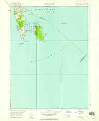
1948 Map of Sconticut Neck
USGS Topo · Published 1958About this map
Sconticut Neck and the surrounding coastal waters of Buzzards Bay define this 1948 survey of the Fairhaven shoreline. The landscape is dominated by narrow peninsulas and small islands, including West Island and Long Island, which are connected to the mainland by the Causeway and Long Island Road. These physical links illustrate the mid-century development of this maritime community as it expanded toward Sconticut Point and the rocky outcrops of the sound.
Find a feature on this map
29 named features on this map. Tap any name to fly to it.
Don’t see what you’re looking for? This feature index may not catch every label — zoom into the map to look around manually.
Map Details
Editions of this 1948 Sconticut Neck Map
This is the sole edition of this map. No revisions or reprints were ever made.
Other maps of this area

1885 · New Bedford
USGS Topo · 1:62,500

1886 · Falmouth
USGS Topo · 1:62,500

1887 · Gay Head
USGS Topo · 1:62,500

1888 · New Bedford
USGS Topo · 1:62,500

1888 · Falmouth
USGS Topo · 1:62,500

1889 · Gay Head
USGS Topo · 1:62,500

1893 · Gay Head
USGS Topo · 1:62,500

1893 · Falmouth
USGS Topo · 1:62,500

1893 · New Bedford
USGS Topo · 1:62,500

1915 · Falmouth
USGS Topo · 1:62,500