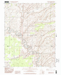
1997 Map of Scorpion Gulch
USGS Topo · Published 2002About this map
The Escalante River snakes through a complex network of canyons and high plateaus in this late 20th-century survey of the Utah wilderness. This landscape is defined by its dramatic elevation changes, where the river's deep incisions contrast sharply with the broad expanses of Baker Bench and East Bench. Located within the Glen Canyon National Recreation Area, the map records a wild and largely undeveloped terrain where water has carved out features such as Scorpion Gulch and the winding reaches of Moody Canyon. The boundary between Garfield Co and Kane Co cuts across the southern portion of the sheet, dividing a region shaped by the drainage patterns of Middle Moody Canyon and East Canyon. This 1997 photoinspection provides a detailed look at the geomorphology of the Escalante basin before modern digital mapping became standard.
Find a feature on this map
11 named features on this map. Tap any name to fly to it.
Don’t see what you’re looking for? This feature index may not catch every label — zoom into the map to look around manually.
Map Details
Editions of this 1997 Scorpion Gulch Map
This is the sole edition of this map. No revisions or reprints were ever made.
Other maps of this area

1886 · Escalante
USGS Topo · 1:250,000

1886 · Henry Mountains
USGS Topo · 1:250,000

1892 · Henry Mountains
USGS Topo · 1:250,000

1953 · Circle Cliffs 4 NW
USGS Topo · 1:24,000

1953 · Mt Pennell 3 NW
USGS Topo · 1:24,000

1953 · Mt Pennell 3 SW
USGS Topo · 1:24,000

1953 · Circle Cliffs 4 NE
USGS Topo · 1:24,000

1953 · Circle Cliffs 4 SW
USGS Topo · 1:24,000

1953 · The Rincon
USGS Topo · 1:62,500

1953 · Hall Mesa
USGS Topo · 1:62,500