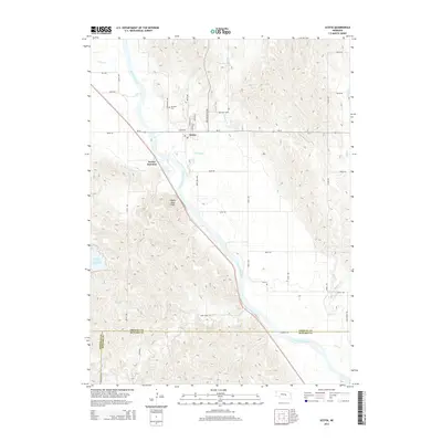
2014 Map of Scotia
USGS Topo · Published 2014About this map
Scotia sits at the heart of this Central Nebraska landscape, where the valley of the North Loup River meets a network of vital waterways and early irrigation works. The town’s grid is clearly defined by historic thoroughfares like Logan Ave and Ericson Scotia Ave, serving as a hub for the surrounding agricultural community. To the northwest, the Mt Hope Cem provides a point of genealogical interest, while the Ord-North Loup Canal highlights the region's managed water system. The terrain rises sharply at Happy Jack Peak, overlooking the confluence of Mira Cr and the main river channel. Downstream, the Davis Creek Reservoir and the winding paths of Fish Cr and Dry Cr illustrate the complex drainage of the Loup River basin. This survey also records the intersection of local history and nature at Scotia Junction and along the rustic Dead Wood Trl.
Find a feature on this map
41 named features on this map. Tap any name to fly to it.
Don’t see what you’re looking for? This feature index may not catch every label — zoom into the map to look around manually.
Map Details
Editions of this 2014 Scotia Map
This is the sole edition of this map. No revisions or reprints were ever made.
Other maps of this area

1899 · Loup
USGS Topo · 1:125,000

1953 · Cotesfield
USGS Topo · 1:24,000

1953 · North Loup
USGS Topo · 1:24,000

1953 · Scotia NE
USGS Topo · 1:24,000

1953 · Scotia
USGS Topo · 1:24,000

1953 · Loup City SE
USGS Topo · 1:24,000

1953 · Elba
USGS Topo · 1:24,000

1954 · Ord SE
USGS Topo · 1:24,000

1954 · Horace
USGS Topo · 1:24,000

1954 · Greeley
USGS Topo · 1:24,000