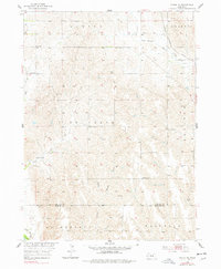
1953 Map of Scotia NE
USGS Topo · Published 1978About this map
The Chicago Burlington and Quincy railroad cuts through the northeastern corner of this rural landscape, marking a vital transit corridor through Greeley County in the early 1950s. This agricultural region is defined by a dense network of country schoolhouses and small community centers, including School No 30, School No 52, and Fairview Sch. These local institutions, alongside Salem Ch, reflect a dispersed but connected social structure typical of Nebraska's mid-century farming districts.
Find a feature on this map
16 named features on this map. Tap any name to fly to it.
Don’t see what you’re looking for? This feature index may not catch every label — zoom into the map to look around manually.
Map Details
Editions of this 1953 Scotia NE Map
2 editions found
Other maps of this area

1899 · Loup
USGS Topo · 1:125,000

1899 · St. Paul
USGS Topo · 1:125,000

1953 · Cotesfield
USGS Topo · 1:24,000

1953 · Scotia NE
USGS Topo · 1:24,000

1953 · Scotia
USGS Topo · 1:24,000

1953 · Elba
USGS Topo · 1:24,000

1954 · Horace
USGS Topo · 1:24,000

1954 · Greeley
USGS Topo · 1:24,000

1954 · Spalding SW
USGS Topo · 1:24,000

1954 · Wolbach
USGS Topo · 1:24,000