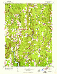
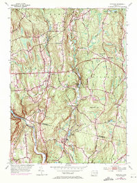
1953 Map of Scotland
USGS Topo · Published 1959About this map
Scotland and the surrounding rural uplands of Windham and New London Counties are depicted here during the early 1950s, characterized by a landscape of small agricultural settlements and prominent ridges. The Shetucket River and Little River carve through the terrain, supporting local water resources like the Hanover Reservoir and Baltic Reservoir. The regional infrastructure is anchored by the New York New Haven and Hartford railroad line which follows the river valley near Pautipaug. Local civic life is visible through the scattered placement of the Howard Valley Church, and several family-named burial grounds including Raymond Cemetery and Bradford Cemetery. This survey captures the traditional New England character of eastern Connecticut before major modern expansion, preserving the locations of hilltop hamlets like Westminster and Parrish Hill alongside historic routes like Old Turnpike Road.
Find a feature on this map
50 named features on this map. Tap any name to fly to it.
Don’t see what you’re looking for? This feature index may not catch every label — zoom into the map to look around manually.
Map Details
Editions of this 1953 Scotland Map
5 editions found
Other maps of this area

1889 · Putnam
USGS Topo · 1:62,500

1889 · Moosup
USGS Topo · 1:62,500

1892 · Woodstock
USGS Topo · 1:62,500

1892 · Norwich
USGS Topo · 1:62,500

1893 · Putnam
USGS Topo · 1:62,500

1893 · Moosup
USGS Topo · 1:62,500

1919 · Putnam
USGS Topo · 1:62,500

1920 · Moosup
USGS Topo · 1:62,500

1921 · Woodstock
USGS Topo · 1:62,500

1943 · Plainfield
USGS Topo · 1:31,680