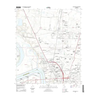
2015 Map of Scotlandville
USGS Topo · Published 2015About this map
The Mississippi River carves the western boundary of this landscape, framing the industrial and academic corridor of north Baton Rouge. This area is anchored by the campus of Southern Univ and A & M Coll, situated near Scott Bluffs overlooking the river. The settlement pattern reveals a dense network of suburban developments and family-named tracts such as McClure Place, Gibbens Place, and Jenkins-Pryce Place, which speak to the long-standing community history of East Baton Rouge Parish.
Find a feature on this map
264 named features on this map. Tap any name to fly to it.
Don’t see what you’re looking for? This feature index may not catch every label — zoom into the map to look around manually.
Map Details
Editions of this 2015 Scotlandville Map
This is the sole edition of this map. No revisions or reprints were ever made.
Other maps of this area

1906 · Bayou Sara
USGS Topo · 1:125,000

1908 · Baton Rouge
USGS Topo · 1:62,500

1939 · Zachary
USGS Topo · 1:62,500

1939 · Baton Rouge
USGS Topo · 1:62,500

1940 · Grosse Tete
USGS Topo · 1:62,500

1953 · Baton Rouge West
USGS Topo · 1:24,000

1953 · Lobdell
USGS Topo · 1:24,000
1953 · Baton Rouge East
USGS Topo · 1:24,000

1953 · Comite
USGS Topo · 1:24,000

1954 · Zachary
USGS Topo · 1:24,000