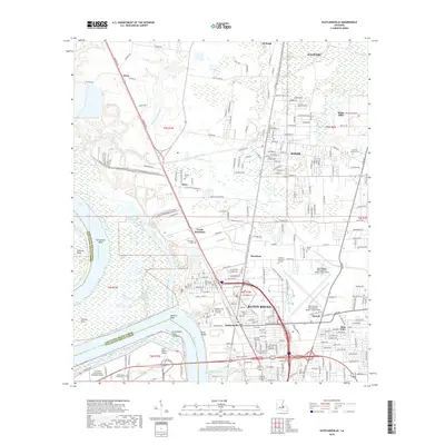
2018 Map of Scotlandville
USGS Topo · Published 2018About this map
The Mississippi River carves the western edge of this landscape, shaping the distinctive curves of Springfield Bend and Mulatto Bend. Along these banks, features like Free Negro Point and the Free Negro Point Crevasse provide specific historical markers for researchers tracing land-use and river management history. To the east, the urban expansion of Baton Rouge and Scotlandville is evident, centered around major institutions such as the Southern Univ and A and M College and the Baton Rouge Metropolitan Airport.
Find a feature on this map
237 named features on this map. Tap any name to fly to it.
Don’t see what you’re looking for? This feature index may not catch every label — zoom into the map to look around manually.
Map Details
Editions of this 2018 Scotlandville Map
This is the sole edition of this map. No revisions or reprints were ever made.
Other maps of this area

1906 · Bayou Sara
USGS Topo · 1:125,000

1908 · Baton Rouge
USGS Topo · 1:62,500

1939 · Zachary
USGS Topo · 1:62,500

1939 · Baton Rouge
USGS Topo · 1:62,500

1940 · Grosse Tete
USGS Topo · 1:62,500

1953 · Baton Rouge West
USGS Topo · 1:24,000

1953 · Lobdell
USGS Topo · 1:24,000
1953 · Baton Rouge East
USGS Topo · 1:24,000

1953 · Comite
USGS Topo · 1:24,000

1954 · Zachary
USGS Topo · 1:24,000