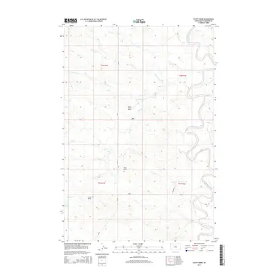
2015 Map of Scott Creek
USGS Topo · Published 2015About this map
The Little Missouri River meanders through the eastern edge of this Harding County landscape, carving a distinct valley through the high plains of South Dakota. The drainage network is particularly dense here, with numerous seasonal watercourses including Scott Cr, Wagoneer Cr, and the aptly named Dipping Vat Cr feeding into the larger river system. These creeks are interrupted by prominent topographic landmarks such as Bleak Butte and Profile Butte, which serve as significant navigational waypoints in an otherwise open terrain.
Find a feature on this map
19 named features on this map. Tap any name to fly to it.
Don’t see what you’re looking for? This feature index may not catch every label — zoom into the map to look around manually.
Map Details
Editions of this 2015 Scott Creek Map
This is the sole edition of this map. No revisions or reprints were ever made.
Other maps of this area

1935 · Buffalo
USGS Topo · 1:125,000

1954 · Lemmon
USGS Topo · 1:250,000

1954 · Ekalaka
USGS Topo · 1:250,000

1956 · Ekalaka
USGS Topo · 1:250,000

1957 · Lemmon
USGS Topo · 1:250,000

1958 · Ekalaka
USGS Topo · 1:250,000

1965 · Ekalaka
USGS Topo · 1:250,000

1973 · Gallup Creek
USGS Topo · 1:24,000

1974 · Caroline Butte
USGS Topo · 1:24,000
1977 · Scott Creek
USGS Topo · 1:24,000