
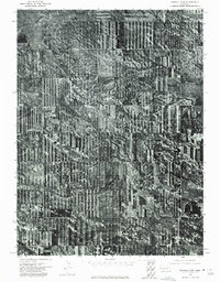
1973 Map of Scotts Bluff 3 SE
USGS Topo · Published 1975About this map
Willow Creek meanders through a landscape of intense agricultural development in Banner County, Nebraska, as seen in this 1973 orthophotomosaic. The map reveals the striking geometry of mid-century farming, characterized by circular irrigation patterns and long, narrow strip-cropping fields that dominate the northern half of the quadrangle. This aerial perspective, prepared by the U.S. Geological Survey using 1:80,000-scale photography, provides an unfiltered look at the intersection of high-plains agriculture and natural landforms. In the southwestern section, the terrain shifts abruptly from the flattened, tilled tableland to the more broken, textured landscape around Gabe Rock. This transition highlights the physical geography that local ranchers and farmers negotiated during the early 1970s, before modern mapping technology standardized the representation of these rural stretches.
Find a feature on this map
2 named features on this map. Tap any name to fly to it.
Don’t see what you’re looking for? This feature index may not catch every label — zoom into the map to look around manually.
Map Details
Editions of this 1973 Scotts Bluff 3 SE Map
This is the sole edition of this map. No revisions or reprints were ever made.
Other maps of this area

1898 · Scotts Bluff
USGS Topo · 1:125,000

1954 · Scottsbluff
USGS Topo · 1:250,000

1958 · Scottsbluff
USGS Topo · 1:250,000

1960 · Murray Lake
USGS Topo · 1:24,000

1973 · Scotts Bluff 4 NW
USGS Topo · 1:24,000

1973 · Kimball 2 NE
USGS Topo · 1:24,000

1973 · Scotts Bluff 4 SW
USGS Topo · 1:24,000
1973 · Kimball 2 NW
USGS Topo · 1:24,000

1973 · Kimball 1 NW
USGS Topo · 1:24,000
1973 · Scotts Bluff 3 SW
USGS Topo · 1:24,000