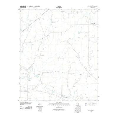
2010 Map of Scottsville
USGS Topo · Published 2010About this map
The Scottsville Oil Field and scattered family burial grounds characterize this area of Harrison County, where the landscape is defined by the winding paths of Harrison Bayou and Quapaw Creek. Small settlements like Scottsville and Leigh anchor the region, connected by a network of rural routes such as Marshall Leigh Rd and Bill Coleman Rd. The presence of several family-named cemeteries, including Mimosa Hall Cemetery and Minneweather Cemetery, offers significant value for genealogical research into the area's established families. Water management is evident through features like Verhalen Lake Dam and Scottsville Lake Dam. To the north, the Karnack Lookout Tower stands as a notable landmark overlooking the drainage basins of Karnack Creek and Haggerty Creek, illustrating the intersection of natural waterways and regional oversight.
Find a feature on this map
44 named features on this map. Tap any name to fly to it.
Don’t see what you’re looking for? This feature index may not catch every label — zoom into the map to look around manually.
Map Details
Editions of this 2010 Scottsville Map
This is the sole edition of this map. No revisions or reprints were ever made.
Other maps of this area

1943 · Waskom
USGS Topo · 1:62,500

1944 · Caddo Lake
USGS Topo · 1:62,500

1945 · Waskom
USGS Topo · 1:62,500

1946 · Caddo Lake
USGS Topo · 1:62,500

1956 · Tyler
USGS Topo · 1:250,000

1958 · Darco
USGS Topo · 1:62,500

1962 · Woodlawn
USGS Topo · 1:24,000
1962 · Potters Point
USGS Topo · 1:24,000
1962 · Karnack
USGS Topo · 1:24,000

1962 · Stricklin Springs
USGS Topo · 1:24,000