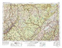
1962 Map of Scranton
USGS Topo · Published 1977About this map
Scranton and Wilkes-Barre anchor the coal-rich Wyoming Valley, where a dense network of towns like Carbondale, Dunmore, and Pittston follows the path of the Lackawanna River. This 1970s revision reflects a mid-century landscape where heavy rail corridors, including the Erie Lackawanna RR and Lehigh Valley RR, navigate the high ridges of the Pocono Mountains and Moosic Mountains. To the east, the map reveals the critical water infrastructure of the New York City watershed, featuring the Ashokan Reservoir, Rondout Res, and Neversink Res within the Catskill Park. The terrain transitions from the industrial heart of Pennsylvania toward the Hudson River valley, passing through the Shawangunk Mountains and the historic grounds of the United States Military Academy near Bear Mountain. The mapping of major thoroughfares like the New York State Thruway highlights the growing connectivity between the mid-Atlantic’s urban and recreational hubs.
Find a feature on this map
83 named features on this map. Tap any name to fly to it.
Don’t see what you’re looking for? This feature index may not catch every label — zoom into the map to look around manually.
Map Details
Editions of this 1962 Scranton Map
2 editions found

Other maps of this area

1888 · Franklin
USGS Topo · 1:62,500

1888 · Morristown
USGS Topo · 1:62,500

1888 · Hackettstown
USGS Topo · 1:62,500

1888 · Lake Hopatcong
USGS Topo · 1:62,500

1888 · Paterson
USGS Topo · 1:62,500

1889 · Scranton
USGS Topo · 1:62,500

1889 · Hazleton
USGS Topo · 1:62,500

1891 · Greenwood Lake
USGS Topo · 1:62,500

1891 · Ramapo
USGS Topo · 1:62,500

1891 · Wilkesbarre
USGS Topo · 1:62,500