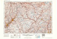
1965 Map of Scranton
USGS Topo · Published 1965About this map
The industrial corridor of the Lackawanna and Susquehanna Valleys dominates this mid-century view, centered on the urban centers of Scranton and Wilkes-Barre. This era reveals the dense network of anthracite-region settlements such as Carbondale, Pittston, and Old Forge as they were connected by the Erie Lackawanna RR and the Lehigh Valley RR. To the east, the landscape shifts toward the high elevations of the Catskill Mountains and Pocono Mountains, where recreation and water management take precedence. Large-scale infrastructure projects including the Ashokan Reservoir and Lake Wallenpaupack illustrate the region's critical role in supplying water and power to distant metropolitan hubs. Military installations like Stewart Air Force Base and the US Military Academy (West Point) anchor the eastern edge along the Hudson, while the newly mapped Northeast Extension Pennsylvania Turnpike indicates the modern shift toward high-speed highway travel.
Find a feature on this map
98 named features on this map. Tap any name to fly to it.
Don’t see what you’re looking for? This feature index may not catch every label — zoom into the map to look around manually.
Map Details
Editions of this 1965 Scranton Map
2 editions found

Other maps of this area

1888 · Franklin
USGS Topo · 1:62,500

1888 · Morristown
USGS Topo · 1:62,500

1888 · Hackettstown
USGS Topo · 1:62,500

1888 · Lake Hopatcong
USGS Topo · 1:62,500

1888 · Paterson
USGS Topo · 1:62,500

1889 · Scranton
USGS Topo · 1:62,500

1889 · Hazleton
USGS Topo · 1:62,500

1891 · Greenwood Lake
USGS Topo · 1:62,500

1891 · Ramapo
USGS Topo · 1:62,500

1891 · Wilkesbarre
USGS Topo · 1:62,500