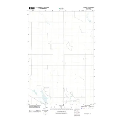
2011 Map of Scranton NE
USGS Topo · Published 2011About this map
Gascoyne Lake and its surrounding drainage systems define this section of Bowman County in the early twenty-first century. The map provides a detailed view of the water management infrastructure in this prairie landscape, specifically the Gascoyne Lake Dam which regulates the local hydrology. To the south and west, the meandering path of Buffalo Creek winds through the terrain, while South Cedar Creek marks the northeastern corner of the quadrangle. The survey illustrates the rural grid system typical of North Dakota's ranching and farming country, documenting the network of section lines and local roads that connect isolated homesteads to the primary transportation corridors. This 2011 edition serves as a clear record of the area's physical geography before any subsequent shifts in land use or water levels altered the shoreline and creek beds.
Find a feature on this map
4 named features on this map. Tap any name to fly to it.
Don’t see what you’re looking for? This feature index may not catch every label — zoom into the map to look around manually.
Map Details
Editions of this 2011 Scranton NE Map
This is the sole edition of this map. No revisions or reprints were ever made.
Other maps of this area

1953 · Dickinson
USGS Topo · 1:250,000

1957 · Dickinson
USGS Topo · 1:250,000

1969 · Scranton
USGS Topo · 1:24,000

1969 · Gascoyne
USGS Topo · 1:24,000

1969 · Reeder
USGS Topo · 1:24,000

1969 · Scranton NE
USGS Topo · 1:24,000

1973 · Warnke Hill
USGS Topo · 1:24,000

1973 · Mineral Springs
USGS Topo · 1:24,000
1973 · Scranton SW
USGS Topo · 1:24,000

1973 · Cedar Lake
USGS Topo · 1:24,000