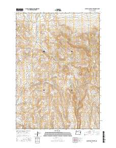
2017 Map of Scratch Post Butte
USGS Topo · Published 2017About this map
Scratch Post Butte and Circle Butte command the high ground of this Malheur County landscape, part of a high-desert terrain where water management is central to the land's utility. Significant effort to capture seasonal runoff is visible through features like Smith Reservoir, Wheaton Cr Reservoir, and Hay Canyon Reservoir. These man-made catchments, alongside natural sources like Kink Spring, define the hydrology of an area where Wheaton Cr and Log Cr navigate the deep relief of Hay Canyon. The passage through this remote section of Oregon is marked by Bonita Rd, which provides access to the higher elevations near Juniper Mtn. The map preserves the complex drainage patterns of numerous seasonal streams, including Lyman Cr and Sheep Cr, as they descend from the buttes into the surrounding basins.
Find a feature on this map
21 named features on this map. Tap any name to fly to it.
Don’t see what you’re looking for? This feature index may not catch every label — zoom into the map to look around manually.
Map Details
Editions of this 2017 Scratch Post Butte Map
This is the sole edition of this map. No revisions or reprints were ever made.
Other maps of this area

1955 · Baker
USGS Topo · 1:250,000

1959 · Baker
USGS Topo · 1:250,000

1964 · Bridgeport
USGS Topo · 1:62,500

1964 · Brogan
USGS Topo · 1:62,500

1964 · Ironside
USGS Topo · 1:62,500

1966 · Clover Creek Ranch
USGS Topo · 1:62,500

1980 · Brogan
USGS Topo · 1:100,000
1990 · Brady Creek
USGS Topo · 1:24,000
1990 · Ironside
USGS Topo · 1:24,000
1990 · Scratch Post Butte
USGS Topo · 1:24,000