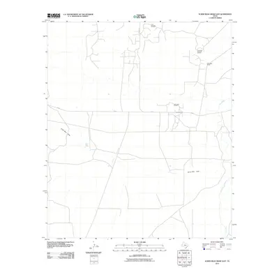
2010 Map of Screw Bean Draw East
USGS Topo · Published 2010About this map
Screw Bean Draw and Salt Creek define the arid drainage patterns of this Reeves County landscape during the early 21st century. The map reveals an environment where petroleum extraction and ranching are the primary human imprints. Industrial activity is concentrated across the Screw Bean Northeast Oil Field, the Screw Bean Oil Field, and the Ford-Geraldine Oil Field to the north, connected by a network of service roads. The Dinwiddie Ranch stands as a notable landmark in the northeast, representing the persistent ranching tradition in West Texas. Important local transit is anchored by FM 652 and the historic Carlsbad Rd. Near the center of the sheet, the presence of Screw Bean Spring highlights a rare water source in this dry region, providing a focal point for understanding the local hydrography and historical land use.
Find a feature on this map
9 named features on this map. Tap any name to fly to it.
Don’t see what you’re looking for? This feature index may not catch every label — zoom into the map to look around manually.
Map Details
Editions of this 2010 Screw Bean Draw East Map
This is the sole edition of this map. No revisions or reprints were ever made.
Other maps of this area

1925 · Orla 2-b
USGS Topo · 1:48,000

1931 · Orla
USGS Topo · 1:62,500

1954 · Van Horn
USGS Topo · 1:250,000

1954 · Pecos
USGS Topo · 1:250,000

1957 · Pecos
USGS Topo · 1:250,000

1958 · Van Horn
USGS Topo · 1:250,000

1968 · Threemile Draw
USGS Topo · 1:24,000

1968 · Orla
USGS Topo · 1:24,000
1968 · Red Bluff
USGS Topo · 1:24,000

1973 · Owl Hills
USGS Topo · 1:24,000