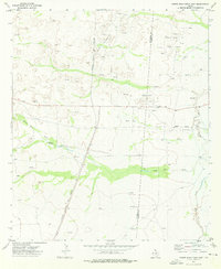
1973 Map of Screw Bean Draw East
USGS Topo · Published 1976About this map
Oil and gas infrastructure dominates this West Texas landscape along the Culberson Co Reeves Co line. The map reveals an intensive network of extraction, featuring the Geraldine Oil Field, Screw Bean Oil Field, and the Screw Bean NE Oil Field. Dozens of individual Oil Wells and a complex system of Pipelines are etched across the terrain, indicating the industrial activity of the early 1970s.
Find a feature on this map
18 named features on this map. Tap any name to fly to it.
Don’t see what you’re looking for? This feature index may not catch every label — zoom into the map to look around manually.
Map Details
Editions of this 1973 Screw Bean Draw East Map
This is the sole edition of this map. No revisions or reprints were ever made.
Other maps of this area

1925 · Orla 2-b
USGS Topo · 1:48,000

1931 · Orla
USGS Topo · 1:62,500

1954 · Van Horn
USGS Topo · 1:250,000

1954 · Pecos
USGS Topo · 1:250,000

1957 · Pecos
USGS Topo · 1:250,000

1958 · Van Horn
USGS Topo · 1:250,000

1968 · Threemile Draw
USGS Topo · 1:24,000

1968 · Orla
USGS Topo · 1:24,000
1968 · Red Bluff
USGS Topo · 1:24,000

1973 · Owl Hills
USGS Topo · 1:24,000