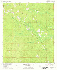
1982 Map of Seaboard
USGS Topo · Published 1982About this map
Seaboard and the small settlements of Tibbie and Topton anchor this corner of southwest Alabama in the early 1980s. The landscape is defined by an intricate network of waterways, including Bilbo Creek, Henson Creek, and the southern Governors Branch, which weave through the timbered terrain. Notable for local history and genealogy research, the map identifies several community pillars such as Chalker Memorial Ch, Howardtown Ch, and Bethel Ch. Transportation follows the Burlington Northern Road, cutting diagonally across the quadrangle alongside family-named landmarks like John Johnston Road and Hawthorn Road. A prominent Gravel Pit near Tibbie and the elevation of High Rocky Hill in the northeast provide insight into the local geology and resource extraction of the era.
Find a feature on this map
27 named features on this map. Tap any name to fly to it.
Don’t see what you’re looking for? This feature index may not catch every label — zoom into the map to look around manually.
Map Details
Editions of this 1982 Seaboard Map
This is the sole edition of this map. No revisions or reprints were ever made.
Other maps of this area

1942 · Deer Park
USGS Topo · 1:62,500

1943 · Deer Park
USGS Topo · 1:62,500

1943 · Citronelle
USGS Topo · 1:62,500

1943 · McIntosh
USGS Topo · 1:62,500

1944 · McIntosh
USGS Topo · 1:62,500

1946 · Citronelle
USGS Topo · 1:62,500

1953 · Hattiesburg
USGS Topo · 1:250,000

1958 · Hattiesburg
USGS Topo · 1:250,000

1974 · Chatom
USGS Topo · 1:24,000

1974 · Vinegar Bend
USGS Topo · 1:24,000