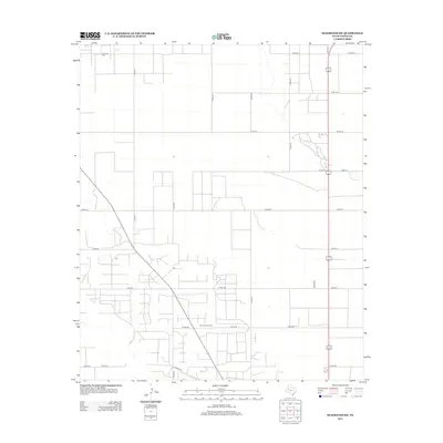
2012 Map of Seagraves SW
USGS Topo · Published 2012About this map
The Seminole Oil Field dominates the southern landscape of this Gaines County region, where industrial infrastructure meets a rigid grid of rural roads. This 2012 survey by the U.S. Geological Survey illustrates a landscape deeply shaped by petroleum extraction, with the northern portion of the quadrangle also supporting operations within the O D C Oil Field. The surveyor's grid is remarkably dense here, with numbered routes like Co Rd-211, Co Rd-209, and Co Rd-201 providing access to numerous well sites and collection points. The concentration of development around junctions such as Co Rd-208 and Co Rd-206 suggests a specialized economy focused on mineral rights and land management. This map provides an essential baseline for understanding the intensive land-use patterns of the Permian Basin at the start of the twenty-first century.
Find a feature on this map
27 named features on this map. Tap any name to fly to it.
Don’t see what you’re looking for? This feature index may not catch every label — zoom into the map to look around manually.
Map Details
Editions of this 2012 Seagraves SW Map
This is the sole edition of this map. No revisions or reprints were ever made.
Other maps of this area

1954 · Hobbs
USGS Topo · 1:250,000

1958 · Hobbs
USGS Topo · 1:250,000

1970 · Seagraves SW
USGS Topo · 1:24,000

1970 · Seminole NE
USGS Topo · 1:24,000

1970 · Seagraves SE
USGS Topo · 1:24,000

1970 · Seagraves
USGS Topo · 1:24,000

1970 · Seagraves NW
USGS Topo · 1:24,000

1970 · Seminole
USGS Topo · 1:24,000

1971 · Paynes Corner
USGS Topo · 1:24,000
1971 · Denver City
USGS Topo · 1:24,000