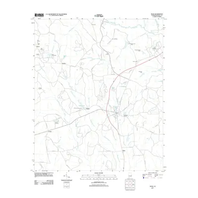
2011 Map of Seale
USGS Topo · Published 2011About this map
Seale and its neighboring rural communities are captured here in East Alabama, where the landscape is defined by the winding paths of Uchee Creek and Watermelon Creek. Small settlements like Dudleys, Hyram, and Colbert are scattered across a terrain dotted with family-named burial grounds, including the Williams Dudley Cemetery and Bush Cemetery. This 2011 survey reflects the enduring character of Russell County, where historic landmarks like the Hyram Post Office and the Sandfort Fire Tower overlook a network of country roads and local water bodies such as McCann Lake and Lake Lenora. The area's water management is evident in numerous structures like the Porter Branch Lake Dam and Mott Lake Dam, which shape the local hydrology alongside several smaller reservoirs. These features provide a look at the agricultural and residential layout of the county as it entered the 21st century.
Find a feature on this map
85 named features on this map. Tap any name to fly to it.
Don’t see what you’re looking for? This feature index may not catch every label — zoom into the map to look around manually.
Map Details
Editions of this 2011 Seale Map
This is the sole edition of this map. No revisions or reprints were ever made.
Other maps of this area

1914 · Seale
USGS Topo · 1:62,500

1949 · Fort Mitchell
USGS Topo · 1:24,000

1950 · Crawford
USGS Topo · 1:24,000

1950 · Seale
USGS Topo · 1:24,000

1950 · Phenix City
USGS Topo · 1:24,000

1950 · Seale
USGS Topo · 1:62,500

1955 · Phenix City
USGS Topo · 1:24,000

1955 · Seale
USGS Topo · 1:24,000

1955 · Crawford
USGS Topo · 1:24,000
1955 · Fort Mitchell
USGS Topo · 1:24,000