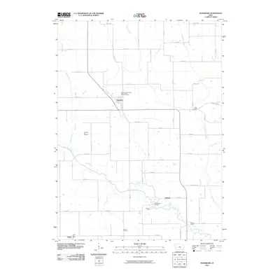
2010 Map of Searsboro
USGS Topo · Published 2010About this map
The North Skunk River meanders through the southern portion of this landscape, anchoring several recreational and infrastructure points in rural Iowa. Along its banks, the McDowell Bridge and public points like Millgrove Access and Robertson Access define the movement across the water. Further north, the town of Searsboro serves as a central hub for the surrounding agricultural grid, which is marked by numerous family and fraternal burial grounds. These include the uniquely named Searsboro International Order of Odd Fellows Cemetery and Cemetery Hill Cemetery, providing significant points of interest for genealogists tracking local lineages. Near the southwestern corner, the settlement of Taintor is noted with its Taintor Post Office, while the hamlet of Stillwell sits just north of the river. The terrain is further defined by a series of north-south waterways, including English Creek and Sugar Creek, which flow toward the primary river valley.
Find a feature on this map
36 named features on this map. Tap any name to fly to it.
Don’t see what you’re looking for? This feature index may not catch every label — zoom into the map to look around manually.
Map Details
Editions of this 2010 Searsboro Map
This is the sole edition of this map. No revisions or reprints were ever made.
Other maps of this area

1910 · Pella
USGS Topo · 1:62,500

1912 · Pella
USGS Topo · 1:62,500

1954 · Des Moines
USGS Topo · 1:250,000

1956 · Des Moines
USGS Topo · 1:250,000

1957 · Des Moines
USGS Topo · 1:250,000

1969 · Des Moines
USGS Topo · 1:250,000

1979 · Montezuma
USGS Topo · 1:24,000

1979 · Searsboro
USGS Topo · 1:24,000

1979 · Grinnell South
USGS Topo · 1:24,000
1979 · Malcom
USGS Topo · 1:24,000