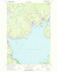
1973 Map of Searsport
USGS Topo · Published 1991About this map
Searsport and the surrounding coastline of Penobscot Bay define this mid-coastal landscape during the early 1970s. The deep-water harbor at Searsport Harbor shows a concentrated maritime industrial hub, with the Bangor and Aroostook railroad line terminating at piers near Mack Point. Inland, the terrain is dotted with small family and community burial grounds, including Smart Cem, Mt Hope Cem, and Bowditch Cem, offering valuable data for genealogists tracing local families. The map details the transition from the developed centers of Belfast and Searsport to more rural areas like Swanville, where recreational sites such as Moose Point State Park and Durham State Forest provide public access to the shore and woods. Significant water bodies like Mc Clure Pond and Goose River drain into the bay, illustrating the local hydrology and its relation to early settlement patterns.
Find a feature on this map
67 named features on this map. Tap any name to fly to it.
Don’t see what you’re looking for? This feature index may not catch every label — zoom into the map to look around manually.
Map Details
Editions of this 1973 Searsport Map
2 editions found
Other maps of this area

1900 · Bucksport
USGS Topo · 1:62,500

1902 · Bucksport
USGS Topo · 1:62,500

1902 · Castine
USGS Topo · 1:62,500

1904 · Castine
USGS Topo · 1:62,500

1905 · Penobscot Bay
USGS Topo · 1:125,000

1915 · Belfast
USGS Topo · 1:62,500

1917 · Belfast
USGS Topo · 1:62,500

1932 · Brooks
USGS Topo · 1:62,500

1941 · Belfast
USGS Topo · 1:62,500

1941 · Castine
USGS Topo · 1:62,500