1983 Map of Sedalia
USGS Topo · Published 1983About this map
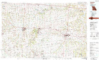
The railroad hubs of Sedalia and Warrensburg anchor this West Central Missouri landscape, illustrating a region defined by the intersection of major transit lines and the meandering courses of the Blackwater River and Lamine River. By the early 1980s, the strategic importance of Whiteman Air Force Base is clearly established between Knob Noster State Park and La Monte, while the historical rail networks of the Missouri Pacific and Missouri-Kansas-Texas lines continue to shape the distribution of smaller communities like Sweet Springs, Holden, and Odessa. Conservation areas such as the Ralph and Martha Perry Memorial State Wildlife Area and Turkey Kearn State Wildlife Area offer a look at the preserved prairie and river bottomlands. This survey captures a mix of established university towns, vital military installations, and several small settlements including Fayetteville, Columbus, and Ernestville.
Find a feature on this map
72 named features on this map. Tap any name to fly to it.
Don’t see what you’re looking for? This feature index may not catch every label — zoom into the map to look around manually.
Map Details
Editions of this 1983 Sedalia Map
This is the sole edition of this map. No revisions or reprints were ever made.
Other maps of this area

1885 · Warrensburg
USGS Topo · 1:125,000

1887 · Clinton
USGS Topo · 1:125,000

1887 · Harrisonville
USGS Topo · 1:125,000

1887 · Sedalia
USGS Topo · 1:125,000

1887 · Warsaw
USGS Topo · 1:125,000

1887 · Butler
USGS Topo · 1:125,000

1887 · Warrensburg
USGS Topo · 1:125,000

1888 · Versailles
USGS Topo · 1:125,000

1888 · Boonville
USGS Topo · 1:125,000

1889 · Lexington
USGS Topo · 1:125,000