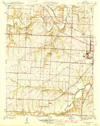
1946 Map of Sedalia West
USGS Topo · Published 1946About this map
The State Fair Grounds anchor the eastern edge of this landscape, just outside Sedalia, where the mid-century city transitions into the rural townships of Prairie and Dresden. This survey captures the region's agricultural and transit character before the heavy expansion of the interstate era, centered on a network of named country schools and family landmarks. Small communities and rail sidings like Fouling Point and Campbell Siding follow the Missouri Pacific line, while the southern reaches of the map are defined by the winding course of Flat Creek and Basin Fork Creek. Local genealogy is well-represented through numerous rural education centers such as Glover Sch, Jackson Sch, and Brown Sch, alongside community anchors like Mc Kee Chapel and the Quisenberry Cem. The presence of Radio Sta KDRO and the Sewage Disposal plant near the city limits provides a clear picture of the municipal infrastructure serving the county seat at this time.
Find a feature on this map
45 named features on this map. Tap any name to fly to it.
Don’t see what you’re looking for? This feature index may not catch every label — zoom into the map to look around manually.
Map Details
Editions of this 1946 Sedalia West Map
2 editions found
Other maps of this area

1887 · Sedalia
USGS Topo · 1:125,000

1894 · Sedalia
USGS Topo · 1:125,000

1939 · Sweet Springs
USGS Topo · 1:62,500

1940 · Sweet Springs
USGS Topo · 1:62,500

1941 · Sweet Springs
USGS Topo · 1:62,500

1944 · Sedalia West
USGS Topo · 1:24,000

1944 · Sedalia East
USGS Topo · 1:24,000

1945 · Sweet Springs
USGS Topo · 1:62,500

1946 · Sedalia West
USGS Topo · 1:24,000

1946 · Sedalia East
USGS Topo · 1:24,000